Abstract
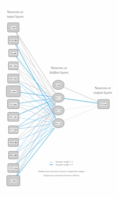
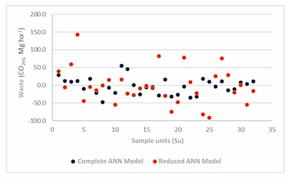
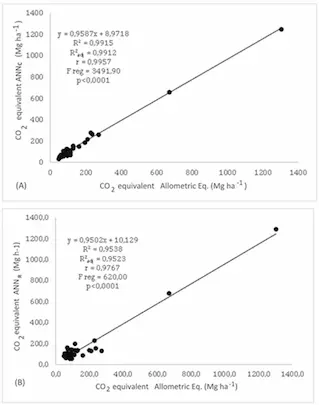
This study developed models to estimate carbon dioxide equivalent (CO2eq) through Artificial Neural Networks (ANNs), using remote sensing (RS) data, including vegetation indices (VI) and reflectance. The experimental area, a 2.37-hectare AFS in Morrinhos do Sul, was evaluated in 2022. Reflectance and IV data were collected with the remotely piloted aircraft (RPA) Phantom 4 Advanced Plus (DJI), equipped with an RGB sensor, and processed using Agisoft Metashape software. The forest inventory, with 32 sampling units georeferenced via GNSS, estimated above-ground biomass, carbon, and CO2eq based on DBH and height data, using species-specific allometric equations. To complement the RS data, images from the MSI Sentinel 2A and WPM CBERS 4A sensors were incorporated into QGIS, where VIs were calculated. Multivariate Factor Analysis (MFA) was applied to understand relationships between variables. A lack of significant correlations was found between CO2eq and optical RS data indicated by the MFA, justifying the use of ANNs, with two models generated: a complete one and a reduced one, the latter using only RS data with importance above 70% in the complete model. Both models presented acceptable statistics, with the complete model being more accurate. It is concluded that these models are efficient in estimating CO2eq in AFSs in the studied region, with the reduced model being an effective and practical tool that requires a smaller number of variables.
Article details
- Volume
- 14
- Number
- e025043
- Received
- 2024-01-14
- Accepted
- 2025-02-11
- Published
- 2025-03-10
Figures